|
|||
 |
 |
 |
|
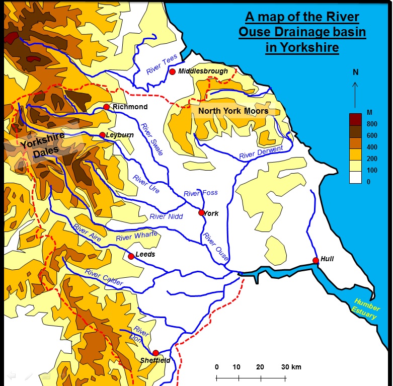
| York Flooding Location
–
Located in the north of Drainage Basin Influences
- There are 8 major influences on the discharge of the river Ouse.
These could be transferred to any major drainage
basin.
Physical factors
1.
Relief
– the relief of the upper course of the river basin in the
2.
Geology and
Geomorphology –
there are seams of Permian Limestone that allow water through its structure
quickly.
There is also a substantial amount of clays that are
impermeable, this water cannot infiltrate the soil and hence gets into the river
quicker – reducing lag time.
3.
Vegetation
– At high altitudes in the upper basin the vegetation is heathers and moor land
that has low interception rates.
There are areas of scattered coniferous trees with
better interception year round, while deciduous trees offer good interception
until they loose their leaves.
Much of the lower basin is farmland offering little
interception.
4.
Soils
– peat soils in the upper basin act like a sponge and absorb much of the summer
precipitation, lowering peak discharge.
From late autumn these stores are full and hence
subsequent water finds its way into the tributaries.
5.
Climate
– The Ouse section of the basin is flat and receives about as much precipitation
(640mm per year) as is lost through evapo-transpiration (540mm per year).
The water that floods
Human Factors
6.
Farming
–
7.
Forestry -
There has been some afforestation in the Ure catchment area.
8.
Urban
Developments –
New housing areas, out of town shopping areas, industrial areas, the widening of
the A1 have all created impermeable surfaces and drains carry storm water
quickly and directly into the river Ouse.
This has happened extensively to the North of
York on |
|||
|
Flood control schemes From North to South
|
|||
 Clifton Ings and embankment |
 Outlet sluice at Clifton Ings |
||
|
Leeman road – Embankments have been built here from residue from the sugar beet
factory.
They are quite far away from the rivers edge to increase
the channel capacity (it can thus hold more water). |
|||
 Embankment at Leeman Road Close up, just behind the dog walker |
 Embankment at Leeman Road |
||
|
Almery terrace – Concrete floodwalls with rubber sealed gates protect these
houses.
The walls are directly in front of the housing and offer
just a little protection. |
|||
 |
 |
||
River channelisation - the River Ouse has been straightened and lined so
that water moves through it efficiently |
|||
|
The
General Accident offices – the bottom floor is set aside for car parking so that
nothing valuable is lost during a
flood.
This is a planning measure to limit flood damage. |
|||
 General Accident Offices |
 Height of floods in the Kings Arms Pub, which sits on the River Ouse |
||
 Source |
|||
| Foss Barrier – This barrier stops the River Ouse water backing up the river Foss ( a tributary) and causing damage to some of York's Most historical buildings. Water from the Foss is pumped into the river Ouse. Are these schemes effective? | |||
 The Foss Barrier |
 The Foss Barrier Pumping station |
||
|
The floods of 2000
In November 2000 for example, despite continued improvements to York’s
flood defences, part of the central area of the city was flooded after a
series of low pressure systems brought heavy rain to the north east and
the worst flooding in Britain for 50 years. 3,000 York residents had to
be evacuated from their homes, and the army was brought in to help. The
big difference about this flood was that it affected areas previously
though to be at little risk. Ironically, only a month earlier York had
hosted the first National Flood Forum, which aimed to give homes and
businesses practical advice about defending property from flooding. In
2000 the floods broke previous records for flooding in York – in 1982
waters had risen to 16 feet 7 inches above normal. Due to its complex
geography and the historic importance of the city, attempts to defend
York against floods continue. So far this has cost approximately £10
million.
The flooding was caused when several depressions swept across Northern
Britain bring lots of rain (35-40mm in 24 hours), this occurred in early
November 2000. This had huge
social impacts, 3000 people were evacuated, and the army had to be
called in. The River Ouse
was 4.8 m above normal level and this caused York race course to be
completely flooded - No racing at the race course!
The economy was also hard hit, one insurance company alone paid
out £12.5 million in flood damage claims between 2000 and 2010 in York.
In 800 claims, at an average of £25,000 per flooded property. The
flooding also cost the City of York Council £1.3m with protecting
properties by sandbags and other means was the biggest single expense,
at £394,000. Over £100,000 was paid to the fire service, and £41,000 to
the army for the help they provided. The council has been able to
reclaim a almost half the total bill from the government but the city
still had to find £772,000 from its own resources. There was also £10
million in lost income because it led to 200,000 fewer visitors coming
to York, plus the economic consequences effects on the Selby to York
railway line. John Prescott pledged a new national recovery team to help
flood victims, with the promise of £51m extra funding for flood defences
and warning systems. Mr
Prescott added that he had asked insurance companies to speed up
payments. Flood defences in
the historic walled city were shored up with 15,000 sandbags in a huge
weekend operation involving the emergency services, army and local
people, it was insufficient for large areas of the town however.
Another response was to open two rest centres in the city for
flood victims and 65,000 sand bags were put into place by 500 army
personnel |
|||
|
|
|||
|
British Civil Defence
website
|
|||
|
|
|||