
4. Meanders Floodplains by rgamesby
Think about it
1) Try this hot potatoes task on Meanders
2) Fully explain how rivers can transform the v-shaped valleys of the upper valley into broader flatter valleys.
3) Describe the map below that shows an abandoned meander
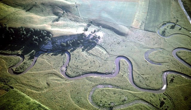
Meanders
Meanders occur in the middle valley and are the result of erosion AND deposition
processes on a river.
In this section of the valley the river erodes laterally and migrates across the valley floor over time, widening the valley. Within the river itself, the fastest current is found on the outside of a bend and the slowest current on the inside of the bend, this can be observed on diagram A. This is because the depth of the water on the outside of the bend is deeper, so there is less friction and hence higher velocities.
Over time, this means that erosion occurs on the outside of meander bends and
deposition occurs on the inside.

Diagram B) a labelled cross section to show the key features of the meander. Note that on the shallower inside of the bend sediment can accumulate to form a slip off slope, whereas on the deeper outside of the bend where the current is faster and erosion operates, a river cliff forms.

In the diagrams below, erosion of the outside of the meander means that the neck of
land becomes narrower and narrower over time.
On the inside of the bend the slow flow encourages the deposition of beaches.
After a long time the neck of land gets totally cut through by erosion processes
such as hydraulic action and abrasion (watch
an animation of this).
This cuts off the meander bend which is totally isolated by deposition leaving an Ox bow lake, which is a crescent shaped lake that will eventually fill with reeds and sediment over time.

Flood plains, Levees and Yazoo streams
Rivers flood on a regular basis.
When rivers flood in the middle valley the cover an area of land known as the
flood plain.
When they flood velocity is slowed and deposition of any rocks being transported
is encouraged.
This deposition leaves a layer of sediment across the whole floodplain.
After several floods there are several layers of sediment (rocks) deep on the
flood plain.
In addition, the largest rocks and most deposition occurs next to the river channel. This leaves a ridge of higher material next to the river channel on both banks of the river known as a levee.


