



Transport and its management: the development of
integrated, efficient and sustainable systems.
Traffic
is a major issue for countries
around the world regardless of the level of
development. MEDC car ownership is high and is
the preferred mode of transport, whilst LEDCs
and NICs have increasing numbers of car owners
and need to find ways of accommodating them.
Vehicles running on fossil fuels pose lots of
problems because of their emissions. Vehicular
emissions can discolour buildings, add acidity
to rainwater, and impact upon health via
respiratory conditions such as asthma. In
addition, traffic can be noisy and unsightly,
and slows down essential emergency service
vehicles and has an economic impact.
People also suffer and road rage is a recent
phenomenon.
The longer goods sit in traffic queues the more
it costs companies to move those goods!
Traffic congestion is also highly wasteful of
fuel.
The UK and strategies to manage traffic
The UK does lots of things to manage the impact
of traffic and to try to reduce the impact of
having too much traffic.
Modifications to vehicles and government policy
There are many modifications to vehicles such
as;
Running cars on unleaded petrol
Making catalytic converters compulsory
Promoting the use of electric and hybrid cars
that pollute less
Ensuring that cars pass an annual emissions test
as part of the MOT
Modifications to the road network
Increasing the size of roads and the number of
lanes, for example the stretch of the A1 next to
Leeds has been upgraded
Congestion charging - the government has placed
electronic readers in London to read car number
plates of cars entering central London - the
cars are then sent a bill for entering the
centre of the city.
Variable speed limits - it is known that if cars
all move together at a constant similar speed
there is less flow break down and less chance of
traffic jams. Reducing a speed limit from 70mph
to 50mph in busy time can keep all traffic
moving.
Charging for road use via toll roads is also a
possibility
Promoting other forms of transport
There are many other possibilities for people to
travel around the UK. The government has tried
to promote other forms of transport in various
ways. The Bike to work scheme allows people to
buy their bike cheaper by paying for it from
their salary before tax is taken off. This means
that they save the tax payable on that salary.
Metro services (e.g. the Tyne and Wear metro)
receive subsidies and investment grants, and the
rail and bus network are also subsidised
(financially supported) by the government to
provide a cheaper service. All of these are more
SUSTAINABLE than reliance on a road network.
Newcastle’s Tyne and Wear Metro
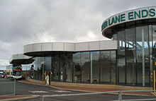
4 Lane Ends Integrated Metro station
The Tyne and Wear Metro is a great case study.
It serves the wider Tyne and Wear area and links
the Eastern coastal areas of Tynemouth and
Whitley Bay, the Western suburbs and the Airport
to the CBD. However, the Metro extends even
further than that, and links Gateshead to
Newcastle, and a new line links Sunderland as
well. The Metro is subsidised to keep prices
low, and runs on electricity so does not pollute
in the city.
The Tyne and Wear Metro is a light rail system
that opened in 1980 and in 2007–2008 provided 40
million public journeys on its network of nearly
78 kilometres (48 mi). It is the second largest
of the three rapid transit metro systems in the
UK, after the London Underground. When the Metro
opened it made great efforts to be the UK's
first integrated public transport system. The
Metro was to cover main trunk journeys, while
buses were reoriented toward shorter local
trips, integrated with the Metro schedule, to
bring passengers to and from Metro stations,
using unified ticketing. The Metro also has
interchange stations such as Four Lane Ends and
Regent Centre, which combined a large parking
facility with a bus and Metro station. It is
still possible to buy Transfare tickets that
combine a Metro and bus journey.
Freiburg
Since the establishment of the first pedestrian
zone in 1973, Freiburg’s traffic and
transportation policy has been distinguished by
the continuous development of the following
co-ordinated elements.
A) By adding new routes, frequencies and travel
comfort, the former tram system was converted
into a modern city-rail system that connects
almost all major city districts. 65% of people
live in the catchment area of a tram stop.
B) The Breisgau-S-Bahn allows good and fast rail
transport connections between the city and the
region. At the main station, it links regional
traffic to intercity railway transport.
C) In 1970, Freiburg had almost no bike paths.
Today (October, 2008) there is a 500 km network
of bike lanes and improved opportunities for
cyclists: 9000 parking sites in the city, links
to the local public transport network (‘Bike and
Ride’) and the bicycle city map.
D)Large parts of the city centre are designated
as pedestrian zones and have been entirely
reconstructed. This upgrading of urban spaces
will continue in the coming years.
E)Pedestrians
and cyclists also benefit from extensive traffic
calming measures in residential areas. Currently
90% of residents live in 30 km per hour zones.
Source – AQA exam paper June 2012

Coolgeography.co.uk by Rob Gamesby is licensed under a Creative Commons Attribution-NonCommercial 3.0 Unported License.
Contact -
robert.gamesby@st-marys.newcastle.sch.uk
Contact via Google Docs form